
Mapa topográfico Warminster
Clique no mapa para exibir a altitude.
Warminster
Warminster Town Hall, at the junction of the High Street and Weymouth Street, was designed c. 1837 by Edward Blore at the expense of the 5th Marquess of Bath; the two-storey front elevation is a replica of Longleat, with the addition of a central bellcote, clock and coat of arms. The building was sold by the district council in 1979.
Sobre este mapa
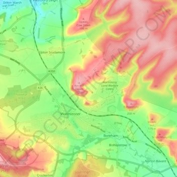
Nome: Mapa topográfico Warminster, altitude, relevo.
Local: Warminster, Wiltshire, England, United Kingdom (51.18948 -2.22830 51.24075 -2.11980)
Altitude média: 143 m
Altitude mínima: 70 m
Altitude máxima: 215 m
Outros mapas topográficos
Clique em um mapa para visualizar sua topografia, sua altitude e seu relevo.
Cley Hill
United Kingdom > England > Wiltshire
Cley Hill (grid reference ST838449) is a prominent hill to the west of Warminster in Wiltshire, England. Its summit has a commanding view of the Wiltshire / Somerset county boundary, at 244 metres (801 ft) elevation. The land is in Corsley parish and is owned by the National Trust.
Altitude média: 157 m