
Obrigado por apoiar este site ❤️
Faça uma doação
Faça uma doação
Mapa topográfico Lhotse
Clique no mapa para exibir a altitude.
Obrigado por apoiar este site ❤️
Faça uma doação
Faça uma doação
Lhotse
Lhotse (Nepali: ल्होत्से, romanized: L'hōtsē [lotse]; Standard Tibetan: ལྷོ་རྩེ, romanized: lho tse, lit. 'South Peak' [l̥otse]; Chinese: 洛子峰) is the fourth-highest mountain on Earth, after Mount Everest, K2, and Kangchenjunga. At an elevation of 8,516 metres (27,940 ft) above sea level, the main summit is on the border between the Tibet Autonomous Region of China and the Khumbu region of Nepal.
Obrigado por apoiar este site ❤️
Faça uma doação
Faça uma doação
Sobre este mapa
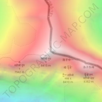
Nome: Mapa topográfico Lhotse, altitude, relevo.
Local: Lhotse, Khumbupasanglahmu, Solukhumbu, Koshi Province, Nepal (27.96194 86.93245 27.96204 86.93255)
Altitude média: 7.391 m
Altitude mínima: 5.780 m
Altitude máxima: 8.499 m
Obrigado por apoiar este site ❤️
Faça uma doação
Faça uma doação
Outros mapas topográficos
Clique em um mapa para visualizar sua topografia, sua altitude e seu relevo.