
Obrigado por apoiar este site ❤️
Faça uma doação
Faça uma doação
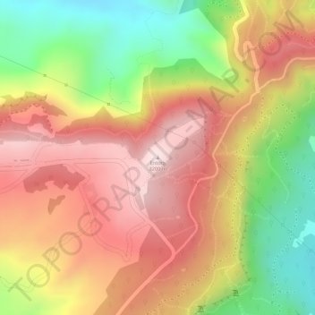
Mapa topográfico Entoto
Clique no mapa para exibir a altitude.
Obrigado por apoiar este site ❤️
Faça uma doação
Faça uma doação
Entoto
The Ethiopian Heritage Trust, a non-profit, non-governmental organization, is working actively to change part of the mountain to its old state, a natural park. Entoto Natural Park is the northeastern rim of Addis Abeba, on the southeastern slopes of Mt. Entoto, covering an area of 1,300 hectares. It is situated at an altitude of between 2,600 and 3,100 meters. Its annual average rainfall and temperature are 1200 mm and 14°C, respectively. The northern rim of the park serves as a watershed between the Abay (Blue Nile) and Awash rivers.
Obrigado por apoiar este site ❤️
Faça uma doação
Faça uma doação
Sobre este mapa
Nome: Mapa topográfico Entoto, altitude, relevo.
Altitude média: 3.019 m
Altitude mínima: 2.771 m
Altitude máxima: 3.198 m
Obrigado por apoiar este site ❤️
Faça uma doação
Faça uma doação