
Obrigado por apoiar este site ❤️
Faça uma doação
Faça uma doação
Mapa topográfico Dhemaji
Clique no mapa para exibir a altitude.
Obrigado por apoiar este site ❤️
Faça uma doação
Faça uma doação
Dhemaji
Dhemaji is located at 27°29′N 94°35′E / 27.48°N 94.58°E / 27.48; 94.58. It has an average elevation of 91 metres (298 feet). Dhemaji is located to the north of the river Brahmaputra. To its north lies the Arunachal Himalayas. To its east lies the state, Arunachal Pradesh and to the west is Lakhimpur, a district of Assam. It has many large and small rivers flowing through it. Some of them are Jiadhal, Gainodi, Dikhari, Dihang, Dimow and Simen. The Subansiri River flows by its western border.
Obrigado por apoiar este site ❤️
Faça uma doação
Faça uma doação
Sobre este mapa
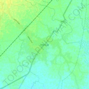
Nome: Mapa topográfico Dhemaji, altitude, relevo.
Local: Dhemaji, Assam, 787057, India (27.43638 94.52296 27.51638 94.60296)
Altitude média: 102 m
Altitude mínima: 95 m
Altitude máxima: 112 m
Obrigado por apoiar este site ❤️
Faça uma doação
Faça uma doação