
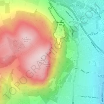
Mapa topográfico McArt's Fort
Mapa interativo
Clique no mapa para exibir a altitude.
Sobre este mapa
Nome: Mapa topográfico McArt's Fort, altitude, relevo.
Altitude média: 165 m
Altitude mínima: 3 m
Altitude máxima: 364 m
Outros mapas topográficos
Clique em um mapa para visualizar sua topografia, sua altitude e seu relevo.
Ballygomartin
United Kingdom > Northern Ireland > County Antrim > Belfast
Ballygomartin, Ligoniel, Belfast, County Antrim, Northern Ireland, United Kingdom
Altitude média: 258 m
Botanic Gardens
United Kingdom > Northern Ireland > County Antrim > Belfast
Botanic Gardens, Queen's Quarter, Belfast, County Antrim, Northern Ireland, United Kingdom
Altitude média: 15 m
Cavehill
United Kingdom > Northern Ireland > County Antrim > Belfast
Cavehill, Belfast, County Antrim, Northern Ireland, BT36 7PN, United Kingdom
Altitude média: 188 m
Edenderry
United Kingdom > Northern Ireland > County Antrim > Belfast
Edenderry, Woodvale, Belfast, County Antrim, Northern Ireland, United Kingdom
Altitude média: 50 m