
Obrigado por apoiar este site ❤️
Faça uma doação
Faça uma doação
Mapa topográfico Omsk
Clique no mapa para exibir a altitude.
Obrigado por apoiar este site ❤️
Faça uma doação
Faça uma doação
Omsk
Omsk is situated in the south of the West Siberian Plain along the banks of the north-flowing Irtysh at its confluence with the Om River. The city has an elevation of 87 meters (285 ft) above mean sea level at its highest point.
Obrigado por apoiar este site ❤️
Faça uma doação
Faça uma doação
Sobre este mapa
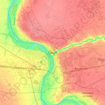
Nome: Mapa topográfico Omsk, altitude, relevo.
Local: Omsk, Omsk Oblast, Siberian Federal District, 644099, Russia (54.83138 73.21153 55.15138 73.53153)
Altitude média: 105 m
Altitude mínima: 62 m
Altitude máxima: 137 m
Obrigado por apoiar este site ❤️
Faça uma doação
Faça uma doação