
Faça uma doação
Mapa topográfico Batagay
Clique no mapa para exibir a altitude.
Faça uma doação
Sobre este mapa
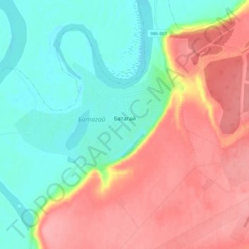
Nome: Mapa topográfico Batagay, altitude, relevo.
Altitude média: 164 m
Altitude mínima: 119 m
Altitude máxima: 218 m
Faça uma doação
Outros mapas topográficos
Clique em um mapa para visualizar sua topografia, sua altitude e seu relevo.
Verkhoyansk
Russia > Sakha Republic > Verkhoyansky Ulus
In this area, temperature inversions consistently form in winter due to the extremely cold and dense air of the Siberian High pooling in deep hollows, so that temperatures increase rather than decrease with higher altitude. In Verkhoyansk it sometimes happens that the average minimum temperatures for January,…
Altitude média: 140 m