
Mapa topográfico Mammoth Lakes
Mapa interativo
Clique no mapa para exibir a altitude.
Mammoth Lakes
Mammoth Lakes is a town in Mono County, California, the county's only incorporated community. It is located immediately to the east of Mammoth Mountain, at an elevation of 7,880 feet (2,400 m). As of the 2010 United States Census, the population was 8,234, reflecting a 16% increase from the 2000 Census.
Sobre este mapa
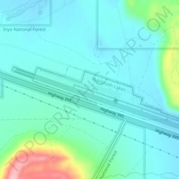
Nome: Mapa topográfico Mammoth Lakes, altitude, relevo.
Altitude média: 2.184 m
Altitude mínima: 2.154 m
Altitude máxima: 2.312 m