
Faça uma doação
Mapa topográfico Kaunertal
Clique no mapa para exibir a altitude.
Faça uma doação
Kaunertal
The Kaunertal valley is 28 km (17 mi) in length and runs southeast from the town of Prutz (884 m) to the Kaunertal Glacier. The valley is traversed by the Faggenbach river, which rises south of the Weißseespitze mountain (3044 m) and flows into the Inn river at Prutz (884 m), the site of a hydroelectric power station. The Gepatsch Reservoir (Gepatsch Stausee), which is located on the upper course of the Fagge river, is 6 km (3.7 mi) in length, has a capacity of 138,000,000 m3, and is formed by a rockfill dam that is 630 m (2,070 ft) long and 130 m (430 ft) high. The dam was constructed in 1961. Water from the lake is used to generate electricity through a pipe system 13 km (8.1 mi) in length, located at the south end of the Kaunertal. The generator facility at Prutz produces 620 million kilowatt hours per year. The lake surface is at an altitude of 1,820 m (5,970 ft).
Faça uma doação
Sobre este mapa
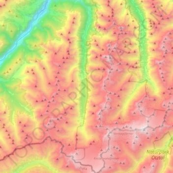
Nome: Mapa topográfico Kaunertal, altitude, relevo.
Local: Kaunertal, Bezirk Landeck, Tyrol, 6524, Austria (46.82251 10.66156 47.07185 10.82162)
Altitude média: 2.399 m
Altitude mínima: 869 m
Altitude máxima: 3.726 m
Faça uma doação
Outros mapas topográficos
Clique em um mapa para visualizar sua topografia, sua altitude e seu relevo.
Faça uma doação
Faça uma doação
Pettneu am Arlberg
Austria > Tyrol > Bezirk Landeck > Gemeinde Pettneu am Arlberg > Pettneu am Arlberg
Altitude média: 1.614 m