
Mapa topográfico Clyde Hill
Mapa interativo
Clique no mapa para exibir a altitude.
Sobre este mapa
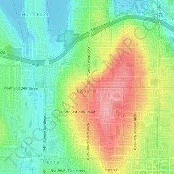
Nome: Mapa topográfico Clyde Hill, altitude, relevo.
Altitude média: 48 m
Altitude mínima: 0 m
Altitude máxima: 118 m
The top elevation is close to 375 feet. There are approximately 21 miles of public roadway that make Clyde Hill very centrally located within the Seattle - Bellevue metro area.