
Mapa topográfico Brunswick
Mapa interativo
Clique no mapa para exibir a altitude.
Sobre este mapa
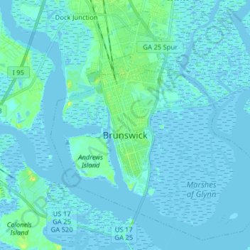
Nome: Mapa topográfico Brunswick, altitude, relevo.
Altitude média: 2 m
Altitude mínima: -3 m
Altitude máxima: 22 m
The city is the lowest in the state of Georgia, with an elevation of only 10 to 14 feet (3.0 to 4.3 m) above sea level. According to the U.S. Census Bureau, Brunswick's land area is 32.4 square miles (83.8 km2). Its total area is 42.4 square miles (109.8 km2); 10.0 square miles (26.0 km2) of this is water.