
Mapa topográfico Egham
Clique no mapa para exibir a altitude.
Sobre este mapa
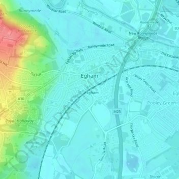
Nome: Mapa topográfico Egham, altitude, relevo.
Local: Egham, Borough of Runnymede, Surrey, England, United Kingdom (51.42219 -0.56124 51.43615 -0.53753)
Altitude média: 25 m
Altitude mínima: 10 m
Altitude máxima: 88 m
Outros mapas topográficos
Clique em um mapa para visualizar sua topografia, sua altitude e seu relevo.
Egham Wick
United Kingdom > England > Surrey > Borough of Runnymede > Englefield Green
Altitude média: 55 m
Cooper's Hill Slopes
United Kingdom > England > Surrey > Borough of Runnymede > Englefield Green
Altitude média: 38 m
Chertsey
United Kingdom > England > Surrey > Borough of Runnymede
Samuel Lewis devotes one of his longest entries to the small town in his 1848 topographical guide to England.
Altitude média: 22 m
Lyn Mushroom Farm
United Kingdom > England > Surrey > Borough of Runnymede > Lyne
Altitude média: 39 m
Chertsey
United Kingdom > England > Surrey > Borough of Runnymede
Samuel Lewis devotes one of his longest entries to the small town in his 1848 topographical guide to England.
Altitude média: 22 m