
Faça uma doação
Mapa topográfico Delta
Clique no mapa para exibir a altitude.
Faça uma doação
Delta
Delta experiences a cold semi-arid climate (Köppen BSk) with hot summers and cold winters. Because of Delta's altitude and aridity, temperatures drop quickly after sunset, especially in the summer. Winters are cold. Daytime highs in the winter are usually above freezing, but nighttime lows drop well below freezing, occasionally falling below 0 °F or −17.8 °C. Delta's climate is similar to that of Salt Lake City, but much more arid.
Faça uma doação
Sobre este mapa
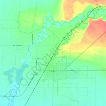
Nome: Mapa topográfico Delta, altitude, relevo.
Local: Delta, Millard County, Utah, United States (39.33856 -112.61453 39.39694 -112.49604)
Altitude média: 1.417 m
Altitude mínima: 1.401 m
Altitude máxima: 1.453 m
Faça uma doação
Outros mapas topográficos
Clique em um mapa para visualizar sua topografia, sua altitude e seu relevo.