
Faça uma doação
Mapa topográfico San Rafael
Clique no mapa para exibir a altitude.
Faça uma doação
Sobre este mapa
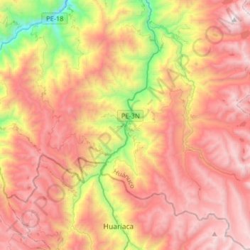
Nome: Mapa topográfico San Rafael, altitude, relevo.
Local: San Rafael, Province of Ambo, Huánuco, Peru (-10.46564 -76.25453 -10.20955 -76.02577)
Altitude média: 3.639 m
Altitude mínima: 2.166 m
Altitude máxima: 4.811 m
Faça uma doação
Outros mapas topográficos
Clique em um mapa para visualizar sua topografia, sua altitude e seu relevo.
Tingo María
Tingo María was considered unreachable until 1936, when the Montaña Road reached the settlement. It was then that the state run Estacion Experimental Agricola was established due to its "comfortable" elevation (2,204 ft). In 1942, the U.S. Government began adding more funding to the station, and by 1960 over…
Altitude média: 841 m
La Bella Durmiente
La Bella Durmiente (Spanish for Sleeping Beauty), also known as Puma Ringri (possibly from Quechua puma cougar, puma, rinri ear, "puma ear"), is a mountain and prominent feature of Tingo María National Park, in the region of Huánuco, Peru. It is located in the district of Mariano Damaso, Leoncio Prado…
Altitude média: 877 m
Faça uma doação
Tingo María
Tingo María was considered unreachable until 1936, when the Montaña Road reached the settlement. It was then that the state run Estacion Experimental Agricola was established due to its "comfortable" elevation (2,204 ft). In 1942, the U.S. Government began adding more funding to the station, and by 1960 over…
Altitude média: 836 m
Faça uma doação
Tingo María
Tingo María was considered unreachable until 1936, when the Montaña Road reached the settlement. It was then that the state run Estacion Experimental Agricola was established due to its "comfortable" elevation (2,204 ft). In 1942, the U.S. Government began adding more funding to the station, and by 1960 over…
Altitude média: 841 m
Faça uma doação
Faça uma doação