
Faça uma doação
Mapa topográfico Mission Viejo
Clique no mapa para exibir a altitude.
Faça uma doação
Mission Viejo
A very short portion of California State Route 73 travels within Mission Viejo's city limits. There is a Mission Viejo population and elevation road sign directly beneath the northbound onramp that roughly marks the official city limits which travels down the center of Via Escolar to the rail tracks on either side of the interstate. The entrance to SR 73 from I-5 northbound is located in the nearby city of San Juan Capistrano as well as the off ramp from SR 73 to I-5 in the southbound direction. There are no exits or entrances to SR 73 within Mission Viejo.
Faça uma doação
Sobre este mapa
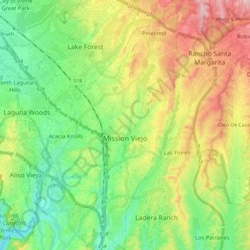
Nome: Mapa topográfico Mission Viejo, altitude, relevo.
Local: Mission Viejo, Orange County, California, United States (33.53383 -117.69588 33.67280 -117.61961)
Altitude média: 179 m
Altitude mínima: 23 m
Altitude máxima: 450 m
Faça uma doação
Outros mapas topográficos
Clique em um mapa para visualizar sua topografia, sua altitude e seu relevo.
Faça uma doação
Faça uma doação
Faça uma doação
Newport Beach
United States > California > Orange County > Newport Beach > Newport Beach
Newport Beach extends in elevation from sea level to the 1,161 ft (354 m) summit of Signal Peak in the San Joaquin Hills, but the official elevation is 25 ft (7.6 m) above sea level at a location of 33°37′0″N 117°53′51″W / 33.61667°N 117.89750°W / 33.61667; -117.89750 (33.616671, −117.897604).
Altitude média: 9 m
Faça uma doação
Faça uma doação
Faça uma doação
Faça uma doação
Faça uma doação
Faça uma doação
Faça uma doação
Faça uma doação