
Mapa topográfico Latteridge
Clique no mapa para exibir a altitude.
Sobre este mapa
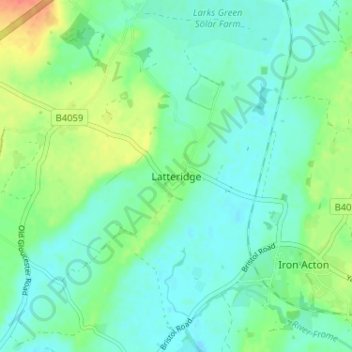
Nome: Mapa topográfico Latteridge, altitude, relevo.
Altitude média: 60 m
Altitude mínima: 47 m
Altitude máxima: 91 m
Outros mapas topográficos
Clique em um mapa para visualizar sua topografia, sua altitude e seu relevo.
Oldbury-upon-Severn
United Kingdom > England > South Gloucestershire > Oldbury on Severn
Altitude média: 11 m
Pucklechurch
United Kingdom > England > South Gloucestershire
The land of Pucklechurch is relatively prominent in elevation compared to surrounding areas and as such it was selected in the Bronze Age as the site of a tumulus (round barrow) at Shortwood Hill.
Altitude média: 98 m
Pucklechurch
United Kingdom > England > South Gloucestershire
Shortwood is located to the east of the A4174 and to the west of Pucklechurch village, sitting lower in the landscape topography against the Pucklechurch ridge and adjacent to Emerson’s Green and Mangotsfield. It is largely a linear settlement (comprising approximately 73 households) washed over by the Green…
Altitude média: 98 m