
Faça uma doação
Mapa topográfico Fort Albany
Clique no mapa para exibir a altitude.
Faça uma doação
Sobre este mapa
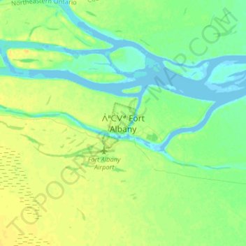
Nome: Mapa topográfico Fort Albany, altitude, relevo.
Altitude média: 9 m
Altitude mínima: -4 m
Altitude máxima: 20 m
Faça uma doação
Outros mapas topográficos
Clique em um mapa para visualizar sua topografia, sua altitude e seu relevo.
Wadsworth Lake
Canada > Ontario > Cochrane District > Unorganized North Cochrane
Altitude média: 323 m
Faça uma doação
Painkiller Lake
Canada > Ontario > Cochrane District > Black River-Matheson Township
Altitude média: 302 m
Borgford Lake
Canada > Ontario > Cochrane District > Black River-Matheson Township
Altitude média: 346 m
Faça uma doação
Kapuskasing
Canada > Ontario > Cochrane District
Kapuskasing lies in the heart of the Great Clay Belt. The topography of the region is very flat, dotted with numerous small lakes and muskeg bogs. Also in the heart of Canada's boreal forest, the region is drained by rivers running north to James Bay. The district is heavily forested, mostly by thick stands of…
Altitude média: 227 m
Arrow Lake
Canada > Ontario > Cochrane District > Unorganized South West Cochrane
Altitude média: 297 m
Faça uma doação
Watersnake Lake
Canada > Ontario > Cochrane District > Fauquier-Strickland Township
Altitude média: 233 m
Faça uma doação
Faça uma doação
Ptarmigan Lake
Canada > Ontario > Cochrane District > Unorganized North Cochrane
Altitude média: 225 m
Faça uma doação
Moose Factory Island
Canada > Ontario > Cochrane District > Unorganized North Cochrane
Altitude média: 4 m
Faça uma doação
Faça uma doação
Cochrane
Canada > Ontario > Cochrane District
Until 1977, Timmins was used as the source for all weather readings attributed to Cochrane except for exceptional extremes, due to the overall similar climate due to proximity and topography. However, in December 1977, Cochrane temperature readings began to be taken from downtown after a noticeable difference…
Altitude média: 262 m
Kabinakagami River
Canada > Ontario > Cochrane District > Unorganized North Cochrane
Altitude média: 250 m
Faça uma doação
Ghost Lake;Pearce Creek
Canada > Ontario > Cochrane District > Unorganized North Cochrane
Altitude média: 213 m
Unorganized South West Cochrane
Canada > Ontario > Cochrane District > Unorganized South West Cochrane
Altitude média: 312 m
Watabeag River
Canada > Ontario > Cochrane District > Black River-Matheson Township
Altitude média: 261 m
Faça uma doação
Moose Factory Island
Canada > Ontario > Cochrane District > Unorganized North Cochrane
Altitude média: 4 m
Kapuskasing
Canada > Ontario > Cochrane District
Kapuskasing lies in the heart of the Great Clay Belt. The topography of the region is very flat, dotted with numerous small lakes and muskeg bogs. Also in the heart of Canada's boreal forest, the region is drained by rivers running north to James Bay. The district is heavily forested, mostly by thick stands of…
Altitude média: 227 m
Faça uma doação
Big Cedar Creek
Canada > Ontario > Cochrane District > Unorganized North Cochrane
Altitude média: 49 m
Faça uma doação
Faça uma doação
Faça uma doação