
Faça uma doação
Mapa topográfico West Mitten
Clique no mapa para exibir a altitude.
Faça uma doação
West Mitten
The Mittens are about 0.6 mi (0.97 km) from the Arizona–Utah state line and West Mitten Butte is 1.1 mi (1.8 km) northeast of the park headquarters. The summit of West Mitten Butte is 6,176 ft (1,882 m) and East Mitten Butte is 6,226 ft (1,898 m) in elevation. The Mittens form a triangle with Merrick Butte about 2⁄3 mi (1.1 km) to the south and, with Sentinel Mesa, a more extensive plateau, towards the northwest. At the End of March and mid-September for a few days only at sunset the Mitten Shadow, a photographer's dream occurs. At this specific time the West Mitten shadow appears on the East Mitten.
Faça uma doação
Sobre este mapa
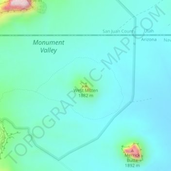
Nome: Mapa topográfico West Mitten, altitude, relevo.
Local: West Mitten, Navajo County, Arizona, United States (36.99046 -110.09553 36.99056 -110.09543)
Altitude média: 1.616 m
Altitude mínima: 1.557 m
Altitude máxima: 1.942 m
Faça uma doação
Outros mapas topográficos
Clique em um mapa para visualizar sua topografia, sua altitude e seu relevo.
Kayenta
United States > Arizona > Navajo County
Kayenta is located at 36°42′43″N 110°15′00″W / 36.71194°N 110.25000°W / 36.71194; -110.25000 (36.7118, -110.2505), at an elevation of 5,700 feet, (1,738 m).
Altitude média: 1.743 m
Faça uma doação
Three Sisters
United States > Arizona > Navajo County
The area is part of the Colorado Plateau. The elevation of the valley floor ranges from 5,000 to 6,000 feet (1,500 to 1,800 m) above sea level. The floor is largely siltstone of the Cutler Group, or sand derived from it, deposited by the meandering rivers that carved the valley. The valley's vivid red color…
Altitude média: 1.664 m
Monument Valley
United States > Arizona > Navajo County
The area is part of the Colorado Plateau. The elevation of the valley floor ranges from 5,000 to 6,000 feet (1,500 to 1,800 m) above sea level. The floor is largely siltstone of the Cutler Group, or sand derived from it, deposited by the meandering rivers that carved the valley. The valley's vivid red color…
Altitude média: 1.650 m
Black Canyon Lake
United States > Arizona > Navajo County
The lake is located 18 miles (29 km) southwest of Heber in the Apache-Sitgreaves National Forests at an elevation of 7,060 feet (2,150 m). Access is restricted in the winter when roads are closed due to snow, generally December to early April.
Altitude média: 2.188 m
Faça uma doação
Faça uma doação