
Faça uma doação
Mapa topográfico Breckenridge
Clique no mapa para exibir a altitude.
Faça uma doação
Breckenridge
At the 2020 United States Census, the town had a total area of 6.047 square miles (15.661 km2), all of it land. The ski area has a total area of 2,880 acres (11.7 km2) of land. The elevation of Breckenridge is 9,600 feet (2,900 m) above sea level.
Faça uma doação
Sobre este mapa
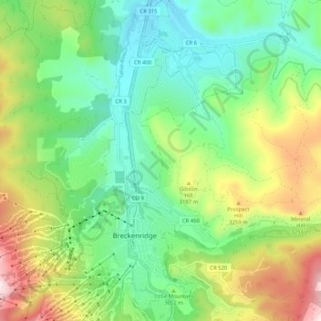
Nome: Mapa topográfico Breckenridge, altitude, relevo.
Local: Breckenridge, Summit County, Colorado, United States (39.46183 -106.07203 39.54046 -106.01439)
Altitude média: 3.072 m
Altitude mínima: 2.802 m
Altitude máxima: 3.809 m
Faça uma doação
Outros mapas topográficos
Clique em um mapa para visualizar sua topografia, sua altitude e seu relevo.
Argentine Pass
United States > Colorado > Summit County
Argentine Pass, elevation 13,207 ft (4,025 m), is a high mountain pass that crosses the Continental Divide in the Front Range of the Rocky Mountains of central Colorado in the United States. Argentine Pass is located on the crest of the Front Range along the boundary southwest of Georgetown and is the highest…
Altitude média: 3.797 m
Quandary Peak
United States > Colorado > Summit County
Quandary Peak is the highest summit of the Tenmile Range in the Rocky Mountains of North America at 14,271 ft (4,350 m). As of 2018, it was the most commonly climbed fourteener in Colorado. It has nearly the same elevation as Castle Peak and Mount Blue Sky. It lies in Summit County and within the White River…
Altitude média: 3.833 m
Faça uma doação