
Mapa topográfico Cave Junction
Mapa interativo
Clique no mapa para exibir a altitude.
Sobre este mapa
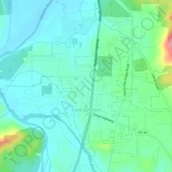
Nome: Mapa topográfico Cave Junction, altitude, relevo.
Local: Cave Junction, Josephine County, Oregon, United States (42.15189 -123.66918 42.18330 -123.62701)
Altitude média: 410 m
Altitude mínima: 378 m
Altitude máxima: 531 m
Cave Junction is located on U.S. Route 199 at its junction with Oregon Route 46. It is about 30 miles or 48 kilometres southwest of Grants Pass, Oregon and 53 miles or 85 kilometres northeast of Crescent City, California. The city lies in the Illinois Valley, on the northwest slope of the Siskiyou Range, at an elevation of about 480 metres (1,570 ft) above MSL. According to the United States Census Bureau, the city has a total area of 1.82 square miles (4.71 km2), of which, 1.81 square miles (4.69 km2) is land and 0.01 square miles (0.03 km2) is water.
Outros mapas topográficos
Clique em um mapa para visualizar sua topografia, sua altitude e seu relevo.
Grants Pass
United States > Oregon > Josephine County
Grants Pass, Josephine County, Oregon, United States
Altitude média: 374 m
Wilderville
United States > Oregon > Josephine County
Wilderville, Josephine County, Oregon, United States
Altitude média: 364 m
O'Brien
United States > Oregon > Josephine County
O'Brien, Josephine County, Oregon, 97534, United States
Altitude média: 454 m
Sunny Valley
United States > Oregon > Josephine County
Sunny Valley, Josephine County, Oregon, 97497, United States
Altitude média: 476 m
Redwood
United States > Oregon > Josephine County
Redwood, Josephine County, Oregon, United States
Altitude média: 300 m
Fruitdale
United States > Oregon > Josephine County > Grants Pass
Fruitdale, Grants Pass, Josephine County, Oregon, 97506, United States
Altitude média: 346 m
Grants Pass
United States > Oregon > Josephine County
Grants Pass, Josephine County, Oregon, United States
Altitude média: 377 m
Williams
United States > Oregon > Josephine County
Williams, Josephine County, Oregon, 97544, United States
Altitude média: 484 m
Merlin
United States > Oregon > Josephine County
Merlin, Josephine County, Oregon, 57526, United States
Altitude média: 308 m
Galice
United States > Oregon > Josephine County > Galice
Galice, Josephine County, Oregon, United States
Altitude média: 402 m
Wolf Creek
United States > Oregon > Josephine County
Wolf Creek, Josephine County, Oregon, 97497, United States
Altitude média: 522 m