
Faça uma doação
Mapa topográfico Hayden Valley
Clique no mapa para exibir a altitude.
Faça uma doação
Hayden Valley
A grassy valley, branching between low ridges, running from the river toward the center of the basin. A small stream rose in this valley, breaking through the ridges to the west in a deep cañon, and falling into the channel of the Yellowstone, which here bears in a northeast course, flowing in view as far as the confluence of the small stream, thence plunged into the Grand Cañon, and hidden from sight. No falls can be seen, but their location is readily detected by the sudden disappearance of the river; beyond this open valley the basin appears to be filled with a succession of low, converging ridges, heavily timbered, and all of about an equal altitude. To the south appears a broad sheet of water -- the Yellowstone Lake.
Faça uma doação
Sobre este mapa
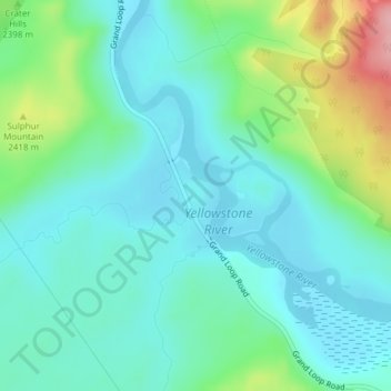
Nome: Mapa topográfico Hayden Valley, altitude, relevo.
Local: Hayden Valley, Park County, Wyoming, United States (44.63362 -110.46622 44.65362 -110.44622)
Altitude média: 2.373 m
Altitude mínima: 2.339 m
Altitude máxima: 2.481 m
Faça uma doação
Outros mapas topográficos
Clique em um mapa para visualizar sua topografia, sua altitude e seu relevo.
Cody
United States > Wyoming > Park County
Cody's elevation is approximately 5016 ft (1,500 m) above sea level. The main part of the city is split across three levels, separated by about 60 feet (18 m).
Altitude média: 1.557 m
Cody
United States > Wyoming > Park County
Cody's elevation is approximately 5016 ft (1,500 m) above sea level. The main part of the city is split across three levels, separated by about 60 feet (18 m).
Altitude média: 1.557 m
Faça uma doação
Cody
United States > Wyoming > Park County
Cody's elevation is approximately 4,997 feet (1,523 m) above sea level. The main part of the city is split across three levels, separated by about 60 feet (18 m).
Altitude média: 1.557 m