
Obrigado por apoiar este site ❤️
Faça uma doação
Faça uma doação
Mapa topográfico Adama
Clique no mapa para exibir a altitude.
Obrigado por apoiar este site ❤️
Faça uma doação
Faça uma doação
Adama
Adama (Oromo: Adaamaa or Hadaamaa, Amharic: አዳማ), formerly Nazreth (Amharic: ናዝሬት), is a city in central Oromia Region, Ethiopia. Adama forms a Special Zone of Oromia and is surrounded by East Shewa Zone. It is located at 8°32′N 39°16′E / 8.54°N 39.27°E / 8.54; 39.27 at an elevation of 1712 meters, 99 km southeast of Ethiopian capital, Addis Ababa. The city sits between the base of an escarpment to the west, and the Great Rift Valley to the east.
Obrigado por apoiar este site ❤️
Faça uma doação
Faça uma doação
Sobre este mapa
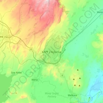
Nome: Mapa topográfico Adama, altitude, relevo.
Local: Adama, Adama Special Zone, Oromia Region, 36, Ethiopia (8.38103 39.11055 8.70103 39.43055)
Altitude média: 1.673 m
Altitude mínima: 1.340 m
Altitude máxima: 2.447 m
Obrigado por apoiar este site ❤️
Faça uma doação
Faça uma doação