
Faça uma doação
Mapa topográfico Barèges
Clique no mapa para exibir a altitude.
Faça uma doação
Barèges
The town is bounded in the north-west by the Bastan river which flows from east to west in a narrow valley through the main village (at an altitude of 1250 m) and through its main inhabited areas. The Bastan forms the northern border of the commune with the commune of Sers.
Faça uma doação
Sobre este mapa
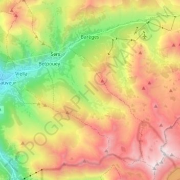
Nome: Mapa topográfico Barèges, altitude, relevo.
Altitude média: 1.844 m
Altitude mínima: 721 m
Altitude máxima: 3.070 m
Faça uma doação
Outros mapas topográficos
Clique em um mapa para visualizar sua topografia, sua altitude e seu relevo.
Hôtellerie du Cirque
France > Occitania > Hautes Pyrenees > Gavarnie-Gèdre > Gavarnie
Altitude média: 1.989 m
Faça uma doação
Cirque de Gavarnie
France > Occitania > Hautes Pyrenees > Gavarnie-Gèdre > Gavarnie
Altitude média: 2.364 m
Lac de Gaube
France > Occitania > Hautes Pyrenees > Cauterets
The lake is situated in an altitude of 1725 m, an egg-shaped form stretching itself along a north–south axis in the valley of Gaube. This steep-sided valley is located at the foot of the Vignemale (3298M). The lake is surrounded by the peak Mayouret (2688 m) to the east, the big Peak of the Paloumères (2720…
Altitude média: 2.079 m
Faça uma doação
Vue sur Cascades et Pont d'Espagne
France > Occitania > Hautes Pyrenees > Cauterets
Altitude média: 1.827 m
Pierrefitte-Nestalas
France > Occitania > Hautes Pyrenees > Pierrefitte-Nestalas > Pierrefitte-Nestalas
Altitude média: 712 m
Faça uma doação
Cirque de Gavarnie
France > Occitania > Hautes Pyrenees > Gavarnie-Gèdre > Gavarnie
Altitude média: 2.364 m
Faça uma doação
Faça uma doação