

Mapa topográfico Kayenta
Clique no mapa para exibir a altitude.
Kayenta
Kayenta is located at 36°42′43″N 110°15′00″W / 36.71194°N 110.25000°W / 36.71194; -110.25000 (36.7118, -110.2505), at an elevation of 5,700 feet, (1,738 m).
Sobre este mapa
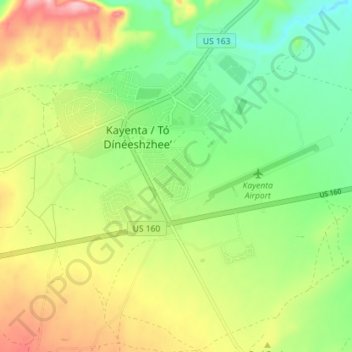
Nome: Mapa topográfico Kayenta, altitude, relevo.
Local: Kayenta, Navajo County, Arizona, United States (36.68686 -110.26292 36.74402 -110.21041)
Altitude média: 1.743 m
Altitude mínima: 1.668 m
Altitude máxima: 1.853 m
Outros mapas topográficos
Clique em um mapa para visualizar sua topografia, sua altitude e seu relevo.
Monument Valley
United States > Arizona > Navajo County
The area is part of the Colorado Plateau. The elevation of the valley floor ranges from 5,000 to 6,000 feet (1,500 to 1,800 m) above sea level. The floor is largely siltstone of the Cutler Group, or sand derived from it, deposited by the meandering rivers that carved the valley. The valley's vivid red color…
Altitude média: 1.675 m
Show Low
United States > Arizona > Navajo County
Show Low is a city in Navajo County, Arizona. It lies on the Mogollon Rim in east central Arizona, at an elevation of 6,345 feet (1,934 m). The city was established in 1870 and incorporated in 1953. According to the 2010 census, the population of the city was 10,660.
Altitude média: 1.957 m

Pinetop Country Club
United States > Arizona > Navajo County > Pinetop Country Club
Altitude média: 2.221 m

Monument Valley
United States > Arizona > Navajo County
The area is part of the Colorado Plateau. The elevation of the valley floor ranges from 5,000 to 6,000 feet (1,500 to 1,800 m) above sea level. The floor is largely siltstone of the Cutler Group, or sand derived from it, deposited by the meandering rivers that carved the valley. The valley's vivid red color…
Altitude média: 1.675 m



Navajo National Monument
United States > Arizona > Navajo County
It is thought that these Ancestral Pueblo people lived in these cave dwellings to optimize the amount of sustainable land to produce crops. By living in these caves, and not on the mesas or the canyon floors, they were able to use this land towards agricultural production to ensure their success in this high…
Altitude média: 2.096 m

Linden
United States > Arizona > Navajo County
Linden is an unincorporated community located in Navajo County, Arizona, United States, just west of the city of Show Low. It is situated atop the Mogollon Rim at an elevation of over 6,000 feet. The community was evacuated in June 2002 due to the Rodeo-Chediski fire, which eventually consumed part of Linden,…
Altitude média: 1.980 m






Turkey Creek
United States > Arizona > Navajo County > Turkey Creek > Sevenmile
Altitude média: 1.610 m

Show Low
United States > Arizona > Navajo County
Show Low is a city in Navajo County, Arizona. It lies on the Mogollon Rim in east central Arizona, at an elevation of 6,345 feet (1,934 m). The city was established in 1870 and incorporated in 1953. According to the 2010 census, the population of the city was 10,660.
Altitude média: 1.957 m
Monument Valley
United States > Arizona > Navajo County
Monument Valley is part of the Colorado Plateau. The elevation of the valley floor ranges from 5,000 to 6,000 feet (1,500 to 1,800 m) above sea level. The floor is largely siltstone of the Cutler Group, or sand derived from it, deposited by the meandering rivers that carved the valley. The valley's vivid red…
Altitude média: 1.675 m
West Mitten
United States > Arizona > Navajo County
The Mittens are about 0.6 mi (0.97 km) from the Arizona–Utah state line and West Mitten Butte is 1.1 mi (1.8 km) northeast of the park headquarters. The summit of West Mitten Butte is 6,176 ft (1,882 m) and East Mitten Butte is 6,226 ft (1,898 m) in elevation. The Mittens form a triangle with Merrick Butte…
Altitude média: 1.616 m
Show Low
United States > Arizona > Navajo County
Show Low is a city in Navajo County, Arizona. It lies on the Mogollon Rim in east central Arizona, at an elevation of 6,345 feet (1,934 m). The city was established in 1870 and incorporated in 1953. According to the 2010 census, the population of the city was 10,660.
Altitude média: 1.957 m
Monument Valley
United States > Arizona > Navajo County
The area is part of the Colorado Plateau. The elevation of the valley floor ranges from 5,000 to 6,000 feet (1,500 to 1,800 m) above sea level. The floor is largely siltstone of the Cutler Group, or sand derived from it, deposited by the meandering rivers that carved the valley. The valley's vivid red color…
Altitude média: 1.675 m



Marsh Pass
United States > Arizona > Navajo County > Tsegi
Marsh Pass, also known as La Puerta Limita, "The Border Gate", is a gap in Navajo County, Arizona. It lies at an elevation of 6,102 feet (1,860 meters) along Laguña Creek. The name of Marsh Pass is thought to come from its location along a chain of swamps and lakes in the pass, that have since been drained by…
Altitude média: 1.961 m