
Obrigado por apoiar este site ❤️
Faça uma doação
Faça uma doação
Mapa topográfico Meta
Clique no mapa para exibir a altitude.
Obrigado por apoiar este site ❤️
Faça uma doação
Faça uma doação
Sobre este mapa
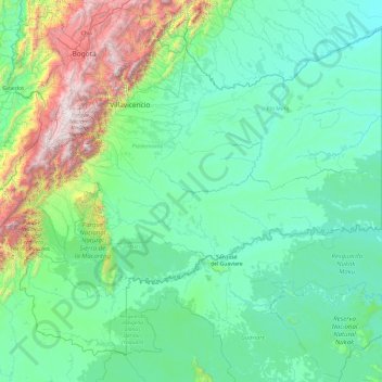
Nome: Mapa topográfico Meta, altitude, relevo.
Local: Meta, RAP (Especial) Central, Colombia (1.60125 -74.93393 4.92514 -71.07741)
Altitude média: 574 m
Altitude mínima: 118 m
Altitude máxima: 4.147 m
Obrigado por apoiar este site ❤️
Faça uma doação
Faça uma doação
Outros mapas topográficos
Clique em um mapa para visualizar sua topografia, sua altitude e seu relevo.
Sincelejo
The geography of Sincelejo is characterized by a hilly landscape which extends from the mountains to the borders of the plateau in the north and south. The small mountain foothills in the municipality span from the marine fluvial plain in the west to the border shared with the town of Palmito. Erosion is…
Altitude média: 121 m
Obrigado por apoiar este site ❤️
Faça uma doação
Faça uma doação
Obrigado por apoiar este site ❤️
Faça uma doação
Faça uma doação