
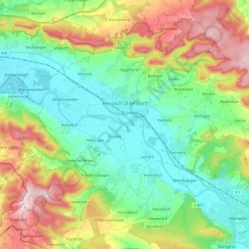
Mapa topográfico Hessisch Oldendorf
Mapa interativo
Clique no mapa para exibir a altitude.
Sobre este mapa
Nome: Mapa topográfico Hessisch Oldendorf, altitude, relevo.
Altitude média: 166 m
Altitude mínima: 53 m
Altitude máxima: 382 m
Outros mapas topográficos
Clique em um mapa para visualizar sua topografia, sua altitude e seu relevo.
Kleinenberg
Duitsland > Nedersaksen > Landkreis Hameln-Pyrmont > Bad Pyrmont
Kleinenberg, Bad Pyrmont, Landkreis Hameln-Pyrmont, Nedersaksen, 32676, Duitsland
Altitude média: 281 m
Bad Pyrmont
Duitsland > Nedersaksen > Landkreis Hameln-Pyrmont
Bad Pyrmont, Landkreis Hameln-Pyrmont, Nedersaksen, 31812, Duitsland
Altitude média: 218 m
Emmerthal
Duitsland > Nedersaksen > Landkreis Hameln-Pyrmont
Emmerthal, Landkreis Hameln-Pyrmont, Nedersaksen, 31860, Duitsland
Altitude média: 160 m
Coppenbrügge
Duitsland > Nedersaksen > Landkreis Hameln-Pyrmont > Coppenbrügge > Coppenbrügge
Coppenbrügge, Landkreis Hameln-Pyrmont, Nedersaksen, 31863, Duitsland
Altitude média: 182 m