
Mapa topográfico Glasgow
Mapa interativo
Clique no mapa para exibir a altitude.
Glasgow
According to the United States Census Bureau, the city has a total area of 1.43 square miles (3.7 km2), all of it land. The town has an elevation of 2,093 feet (638 m) and is nestled in the Milk River Valley.
Sobre este mapa
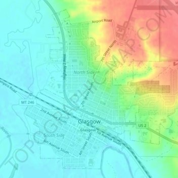
Nome: Mapa topográfico Glasgow, altitude, relevo.
Local: Glasgow, Valley County, Montana, 59230, United States (48.18836 -106.65042 48.21255 -106.61272)
Altitude média: 654 m
Altitude mínima: 633 m
Altitude máxima: 700 m