
Mapa topográfico Alamogordo
Mapa interativo
Clique no mapa para exibir a altitude.
Sobre este mapa
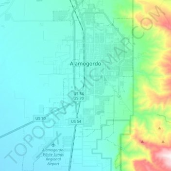
Nome: Mapa topográfico Alamogordo, altitude, relevo.
Altitude média: 1.515 m
Altitude mínima: 1.248 m
Altitude máxima: 2.467 m
As of 2010, Alamogordo had a total area of 19.3 square miles (50.0 km2), all of it land. The city is located at an elevation of 4,336 feet (1,322 m) on the western flank of the Sacramento Mountains and on the eastern edge of the Tularosa Basin. It lies within the Rio Grande rift and in the northernmost part of the Chihuahuan Desert.:36 Tectonic activity is low in the Tularosa Basin. Plants native to the area are typical of the southern New Mexico foothills and include creosote bush, mesquite, saltbush, cottonwood, desert willow, and many species of cactus and yucca.