
Faça uma doação
Mapa topográfico Magat Dam
Clique no mapa para exibir a altitude.
Faça uma doação
Sobre este mapa
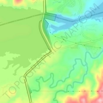
Nome: Mapa topográfico Magat Dam, altitude, relevo.
Local: Magat Dam, Isabela, Cagayan Valley, Philippines (16.80412 121.44772 16.83477 121.45784)
Altitude média: 176 m
Altitude mínima: 104 m
Altitude máxima: 294 m
Faça uma doação
Outros mapas topográficos
Clique em um mapa para visualizar sua topografia, sua altitude e seu relevo.
Ilagan
Abuan River is the main river of the Northern Sierra Madre Natural Park. It has an average elevation of 82 meters above sea level, and feeds the Abuan watershed in the city. Tourists and visitors can explore the diverse animal and plant life in one of the country’s remaining lush virgin forests. On January…
Altitude média: 123 m
Faça uma doação
Faça uma doação
Faça uma doação
Quezon
The physiography of the municipality falls into two basic categories: an alluvial plain and a mountainous terrain. The central plain, where the Poblacion is located, has an elevation of about 100 meters above mean sea level, and is predominantly characterized by low relief and moderately sloping areas. Three…
Altitude média: 113 m