
Mapa topográfico Kepulauan Sangihe
Mapa interativo
Clique no mapa para exibir a altitude.
Kepulauan Sangihe
Topography of the islands mostly consists of hills and steep topography for bigger islands such as Sangihe and Siau. Around 55.4% of land area in the regency has slope above 40%. Soil composition consist of alluvium, which mostly used for residential areas. Elevation varies from 0 to 1,800 meters above sea level depending on the location. Main economic center of the regency, Tahuna, has average elevation of 250 meters above sea level. The regency has three active volcanoes, and experiences frequent earthquakes. Two of three volcanoes are underwater. The region is quite resilient to erosion because of dense vegetation usually found on its coastal region, while most human settlements are found on higher altitudes in the middle of islands. However, because of its steep topography, the region is prone to landslides especially during bad weather.
Sobre este mapa
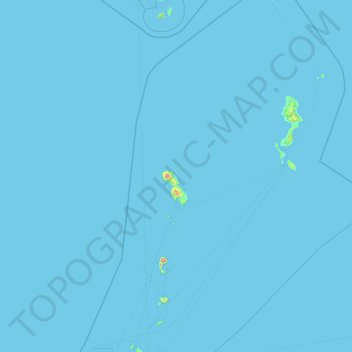
Nome: Mapa topográfico Kepulauan Sangihe, altitude, relevo.
Local: Kepulauan Sangihe, North Sulawesi, Indonesia (1.78935 125.05577 5.56633 126.59089)
Altitude média: 2 m
Altitude mínima: 0 m
Altitude máxima: 1.696 m
Outros mapas topográficos
Clique em um mapa para visualizar sua topografia, sua altitude e seu relevo.