
Obrigado por apoiar este site ❤️
Faça uma doação
Faça uma doação
Mapa topográfico Raren
Clique no mapa para exibir a altitude.
Obrigado por apoiar este site ❤️
Faça uma doação
Faça uma doação
Sobre este mapa
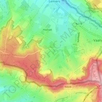
Nome: Mapa topográfico Raren, altitude, relevo.
Local: Raren, Vaals, Limburg, Nederland, 6291 NN, Nederland (50.74680 5.97004 50.78680 6.01004)
Altitude média: 222 m
Altitude mínima: 146 m
Altitude máxima: 332 m
Obrigado por apoiar este site ❤️
Faça uma doação
Faça uma doação