
Faça uma doação
Mapa topográfico Virbhadra
Clique no mapa para exibir a altitude.
Faça uma doação
Sobre este mapa
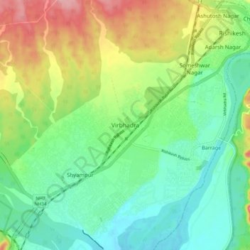
Nome: Mapa topográfico Virbhadra, altitude, relevo.
Altitude média: 361 m
Altitude mínima: 316 m
Altitude máxima: 443 m
Faça uma doação
Outros mapas topográficos
Clique em um mapa para visualizar sua topografia, sua altitude e seu relevo.
Bhagirathi River
The Bhilangna itself rises at the foot of the Khatling Glacier (elevation 3,717 m (12,195 ft)) approximately 50 km (31 mi) south of Gaumukh.
Altitude média: 2.256 m
Faça uma doação
Faça uma doação
Faça uma doação
Gangotri National Park
India > Uttarakhand > Bhatwari
The park harbors Western Himalayan subalpine conifer forests at lower elevations and Western Himalayan alpine shrub and meadows at higher elevations. Vegetation consist of chirpine deodar, fir, spruce, oak and rhododendrons.
Altitude média: 5.008 m
Faça uma doação
Faça uma doação
Faça uma doação
Faça uma doação
Haldwani
Haldwani is located at 29°13′N 79°31′E / 29.22°N 79.52°E / 29.22; 79.52, in the Nainital district on the right bank of the Gaula River. Geologically, Haldwani is settled on a piedmont grade (called Bhabhar) where the mountain rivers go underground to re-emerge in the Indo-Gangetic plain. The…
Altitude média: 523 m
Ramganga Dam
India > Uttarakhand > Kotdwara
The dam is a 128 m (420 ft) tall and 630 m (2,067 ft) long earth and rock-fill embankment dam with 10,000,000 m3 (13,079,506 cu yd) of fill. The dam's spillway is controlled by five gates and has a maximum discharge of 8,467 m3/s (299,009 cu ft/s). To support the reservoir's elevation, there is a 72 m (236 ft)…
Altitude média: 389 m
Faça uma doação
Faça uma doação
Faça uma doação
Faça uma doação