
Faça uma doação
Mapa topográfico Chiang Mai Province
Clique no mapa para exibir a altitude.
Faça uma doação
Chiang Mai Province
Chiang Mai Province is about 685 km (426 mi) from Bangkok in the Mae Ping River basin and is on average at 300 m (1,000 ft) elevation. Surrounded by the mountain ranges of the Thai highlands, it covers an area of approximately 20,107 km2 (8,000 sq mi). The mountains of the Daen Lao Range (ทิวเขาแดนลาว) at the north end of the province, the Thanon Thong Chai Range (เทือกเขาถนนธงชัย) with the highest mountain in Thailand, Doi Inthanon at 2,565 metres (8,415 ft), stretching in a north–south direction, and the Khun Tan Range in the east of the province are covered by rain forest. The Mae Ping, one of the major tributaries of the Chao Phraya River, originates in the Daen Lao mountains. Several national parks are in the province: Doi Inthanon, Doi Suthep-Pui, Ob Luang, Sri Lanna, Huai Nam Dang, Mae Wang, and Pha Daeng.
Faça uma doação
Sobre este mapa
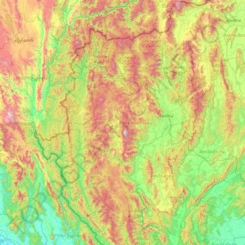
Nome: Mapa topográfico Chiang Mai Province, altitude, relevo.
Local: Chiang Mai Province, Thailand (17.24833 98.08083 20.14758 99.57585)
Altitude média: 649 m
Altitude mínima: -1 m
Altitude máxima: 2.541 m
Faça uma doação
Outros mapas topográficos
Clique em um mapa para visualizar sua topografia, sua altitude e seu relevo.