
Faça uma doação
Mapa topográfico Kiawah Island
Clique no mapa para exibir a altitude.
Faça uma doação
Kiawah Island
Kiawah Island features a low-lying, sandy topography typical of barrier islands along the southeastern coast of the United States. The island's average elevation is about 10 feet above sea level, with some areas reaching slightly higher. Its terrain is characterized by broad, flat beaches that gently slope into the Atlantic Ocean, interspersed with lush maritime forests and salt marshes. These ecosystems create a rich biodiversity, supporting a variety of wildlife. The landscape includes both freshwater lagoons and saltwater estuaries, contributing to its unique ecological environment. Overall, Kiawah Island's topography offers a serene natural setting that enhances its appeal as a vacation destination.
Faça uma doação
Sobre este mapa
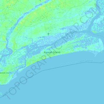
Nome: Mapa topográfico Kiawah Island, altitude, relevo.
Altitude média: 2 m
Altitude mínima: -3 m
Altitude máxima: 13 m
Faça uma doação
Outros mapas topográficos
Clique em um mapa para visualizar sua topografia, sua altitude e seu relevo.
Faça uma doação
Saint Andrews Heights
United States > South Carolina > Charleston County > Charleston
Altitude média: 5 m
Jamestown Estates
United States > South Carolina > Charleston County > James Island
Altitude média: 4 m
Brook Green Meadow
United States > South Carolina > Charleston County > Mount Pleasant
Altitude média: 4 m
Faça uma doação
Faça uma doação
Faça uma doação
Camp Saint Christopher
United States > South Carolina > Charleston County > Seabrook Island
Altitude média: 2 m
Faça uma doação
Faça uma doação
North Charleston Wannamaker County Park
United States > South Carolina > Charleston County > North Charleston
Altitude média: 8 m
Forest Park
United States > South Carolina > Charleston County > Charleston > Maryville
Altitude média: 5 m
Faça uma doação
Faça uma doação
Faça uma doação
Liberty Hill
United States > South Carolina > Charleston County > North Charleston
Altitude média: 7 m
Saint Andrews Heights
United States > South Carolina > Charleston County > Charleston
Altitude média: 5 m
Faça uma doação
Ashley Junction
United States > South Carolina > Charleston County > North Charleston
Altitude média: 7 m
Camp Saint Christopher
United States > South Carolina > Charleston County > Seabrook Island
Altitude média: 2 m
Faça uma doação
Deerwood Heights
United States > South Carolina > Charleston County > North Charleston
Altitude média: 8 m
Northwood Estates
United States > South Carolina > Charleston County > North Charleston > Northwood Estates
Altitude média: 8 m
Faça uma doação
North Charleston
United States > South Carolina > Charleston County > North Charleston
Altitude média: 5 m
Country Club Estates
United States > South Carolina > Charleston County > Charleston
Altitude média: 3 m