
Faça uma doação
Mapa topográfico Calapan
Clique no mapa para exibir a altitude.
Faça uma doação
Calapan
The overall land characteristic is a wide plain with rivers, interspersed with wetlands at the seacoast periphery. The highest elevation is 187 m (614 ft) above sea level at Bulusan Hill, a 6-kilometre (3.7 mi) long landform east of the city, which interrupts the mostly flat terrain north-east of the Halcon-Baco Mountain Range.
Faça uma doação
Sobre este mapa
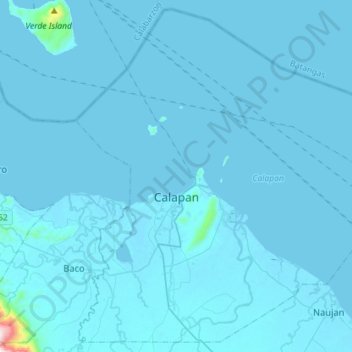
Nome: Mapa topográfico Calapan, altitude, relevo.
Local: Calapan, Oriental Mindoro, Mimaropa, Philippines (13.29974 121.09781 13.56273 121.38299)
Altitude média: 12 m
Altitude mínima: -2 m
Altitude máxima: 843 m
Faça uma doação
Outros mapas topográficos
Clique em um mapa para visualizar sua topografia, sua altitude e seu relevo.
Calapan
Philippines > Oriental Mindoro
The overall land characteristic is a wide plain with rivers, interspersed with wetlands at the seacoast periphery. The highest elevation is 187 m (614 ft) above sea level at Bulusan Hill, a 6-kilometre (3.7 mi) long landform east of the city, which interrupts the mostly flat terrain north-east of the…
Altitude média: 40 m
Faça uma doação
Faça uma doação
Faça uma doação
Faça uma doação
Faça uma doação
Baco
Philippines > Oriental Mindoro
Majority of the barangays of the municipality are in lowland areas or below 500 meters above sea level (MASL) and cover 41.88 percent of the total land area (13,035.58 ha). The three largest barangays, which cover most of the forestland, have an elevation that ranges from 500-1,000 and greater than 1,000…
Altitude média: 14 m
Faça uma doação
Mount Halcon
Philippines > Oriental Mindoro
Mount Halcon (Filipino: Bundok Halcon) and (Spanish: Monte Halcón) is the highest mountain in Mindoro. According to the new data released by Oriental Mindoro peakvisor as of 2022, it has an elevation of 2,616 metres (8,583 ft) above sea level, higher than the previous estimates of 2,586 m (8,484 ft) although…
Altitude média: 2.121 m
Faça uma doação
Roxas
Philippines > Oriental Mindoro
The municipal center of Roxas is situated at approximately 12° 35' North, 121° 31' East, in the island of Mindoro. Elevation at these coordinates is estimated at 10.5 meters (34 ft) above mean sea level.
Altitude média: 7 m
Faça uma doação
Faça uma doação
Faça uma doação
Faça uma doação
Faça uma doação
Faça uma doação
Faça uma doação
Faça uma doação
Faça uma doação
Faça uma doação
Faça uma doação
Faça uma doação
Faça uma doação
Faça uma doação
Faça uma doação
Baco
Philippines > Oriental Mindoro
Majority of the barangays of the municipality are in lowland areas or below 500 meters above sea level (MASL) and cover 41.88 percent of the total land area (13,035.58 ha). The three largest barangays, which cover most of the forestland, have an elevation that ranges from 500-1,000 and greater than 1,000…
Altitude média: 14 m
Faça uma doação
Faça uma doação
Faça uma doação