
Obrigado por apoiar este site ❤️
Faça uma doação
Faça uma doação
Mapa topográfico Chesney
Clique no mapa para exibir a altitude.
Obrigado por apoiar este site ❤️
Faça uma doação
Faça uma doação
Sobre este mapa
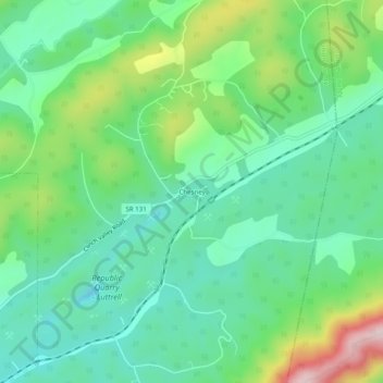
Nome: Mapa topográfico Chesney, altitude, relevo.
Altitude média: 403 m
Altitude mínima: 297 m
Altitude máxima: 654 m
Obrigado por apoiar este site ❤️
Faça uma doação
Faça uma doação
Outros mapas topográficos
Clique em um mapa para visualizar sua topografia, sua altitude e seu relevo.
Big Ridge State Park
United States > Tennessee > Union County
Big Ridge State Park is located in the Appalachian Ridge-and-Valley range, which is characterized by narrow elongate ridges flanked by fertile stream valleys. The park's topography is dominated by three such ridge systems running roughly parallel to one another, the two northernmost of which are bisected by…
Altitude média: 352 m