
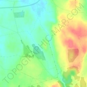
Mapa topográfico Ballinknockane
Mapa interativo
Clique no mapa para exibir a altitude.
Sobre este mapa
Nome: Mapa topográfico Ballinknockane, altitude, relevo.
Altitude média: 27 m
Altitude mínima: 1 m
Altitude máxima: 64 m
Outros mapas topográficos
Clique em um mapa para visualizar sua topografia, sua altitude e seu relevo.
Knocknabooly East
Ireland > The Municipal District of Adare — Rathkeale
Knocknabooly East, Loghill, The Municipal District of Adare — Rathkeale, County Limerick, Munster, Ireland
Altitude média: 105 m
Glendiheen
Ireland > The Municipal District of Adare — Rathkeale
Glendiheen, Dunmoylan East, The Municipal District of Adare — Rathkeale, County Limerick, Munster, Ireland
Altitude média: 167 m
Shanagolden
Ireland > The Municipal District of Adare — Rathkeale
Shanagolden, The Municipal District of Adare — Rathkeale, County Limerick, Munster, Ireland
Altitude média: 40 m
Pallaskenry
Ireland > The Municipal District of Adare — Rathkeale
Pallaskenry, The Municipal District of Adare — Rathkeale, County Limerick, Munster, Ireland
Altitude média: 11 m
Loghill
Ireland > The Municipal District of Adare — Rathkeale
Loghill, The Municipal District of Adare — Rathkeale, County Limerick, Munster, Ireland
Altitude média: 69 m
Inchinclare
Ireland > The Municipal District of Adare — Rathkeale
Inchinclare, Ballynabanoge, The Municipal District of Adare — Rathkeale, County Limerick, Munster, Ireland
Altitude média: 41 m
Clonshire Beg
Ireland > The Municipal District of Adare — Rathkeale
Clonshire Beg, Croagh, The Municipal District of Adare — Rathkeale, County Limerick, Munster, Ireland
Altitude média: 13 m
Foynes Island
Ireland > The Municipal District of Adare — Rathkeale
Foynes Island, Shanagolden, The Municipal District of Adare — Rathkeale, County Limerick, Munster, Ireland
Altitude média: 10 m
Kildimo
Ireland > The Municipal District of Adare — Rathkeale
Kildimo, The Municipal District of Adare — Rathkeale, County Limerick, Munster, Ireland
Altitude média: 14 m