
Faça uma doação
Mapa topográfico Kearny
Clique no mapa para exibir a altitude.
Faça uma doação
Kearny
Kearny Airport is a general aviation airport located in the southern section of the town. In 2003 it received the Arizona Department of Transportation's Airport of the Year award. The airport has a single asphalt runway, 3,400 feet (1,000 m) in length and 60 feet (18 m) in width, with a field elevation of 1,833 feet (559 m) above mean sea level.
Faça uma doação
Sobre este mapa
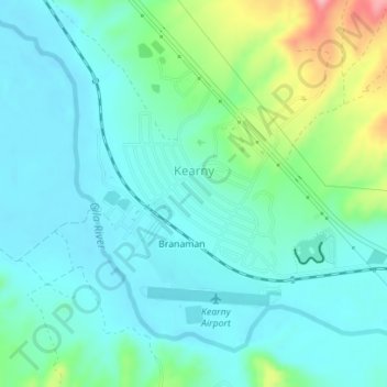
Nome: Mapa topográfico Kearny, altitude, relevo.
Local: Kearny, Pinal County, Arizona, 85237, United States (33.04067 -110.92170 33.06989 -110.89529)
Altitude média: 578 m
Altitude mínima: 549 m
Altitude máxima: 678 m
Faça uma doação
Outros mapas topográficos
Clique em um mapa para visualizar sua topografia, sua altitude e seu relevo.
San Manuel
United States > Arizona > Pinal County
San Manuel is located at 32°36′18″N 110°38′0″W / 32.60500°N 110.63333°W / 32.60500; -110.63333 (32.605048, -110.633340), in the San Pedro River Valley at an elevation of about 3,500 feet (1,100 m). San Manuel is approximately 45 miles (72 km) northeast of Tucson.
Altitude média: 991 m
Biosphere 2 Research Center
United States > Arizona > Pinal County
The glass and spaceframe facility is located in Oracle, Arizona at the base of the Santa Catalina Mountains, about 50 minutes north of Tucson. Its elevation is around 4,000 feet (1,200 m) above sea level.
Altitude média: 1.159 m
Arizona City
United States > Arizona > Pinal County
Arizona City itself is mostly flat, lying in the Santa Cruz Valley in the center of three low mountain ranges; the Sawtooth Mountains to the south, the Picacho Mountains to the east, and the Casa Grande Mountains to the north. Picacho Peak, a prominent peak with a summit elevation of 3,374 feet (1,028 m), is…
Altitude média: 459 m
Faça uma doação
Faça uma doação
Apache Junction
United States > Arizona > Pinal County > Apache Junction > Apache Junction
Altitude média: 524 m
Faça uma doação