
Faça uma doação
Mapa topográfico Owenyo
Clique no mapa para exibir a altitude.
Faça uma doação
Sobre este mapa
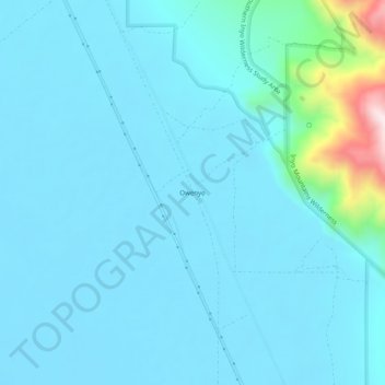
Nome: Mapa topográfico Owenyo, altitude, relevo.
Local: Owenyo, Inyo County, California, United States (36.65827 -118.06425 36.69827 -118.02425)
Altitude média: 1.171 m
Altitude mínima: 1.115 m
Altitude máxima: 1.669 m
Faça uma doação
Outros mapas topográficos
Clique em um mapa para visualizar sua topografia, sua altitude e seu relevo.
Olancha
United States > California > Inyo County
Olancha (Timbisha: Pakwa' si) is a census designated place in Inyo County of the U.S. state of California. Olancha is located on U.S. Route 395 in California, 37 miles (60 km) south-southeast of Independence, at an elevation of 3658 feet (1115 m). As of the 2010 census, the population was 192, up from 134 at…
Altitude média: 1.200 m
Faça uma doação
Cartago
United States > California > Inyo County
Cartago (Spanish for "Carthage") is a census-designated place in Inyo County, California, United States. Cartago is located on the west side of Owens Lake 3 miles (4.8 km) north-northwest of Olancha, at an elevation of 3629 feet (1106 m). The population was 92 at the 2010 census, down from 109 at the 2000…
Altitude média: 1.152 m
Faça uma doação
Darwin
United States > California > Inyo County
Darwin is an unincorporated mining community in Inyo County, California, United States. It is located 22 miles (35 km) southeast of Keeler, at an elevation of 4,790 ft (1,460 m). The population was 43 at the 2010 census, down from 54 at the 2000 census.
Altitude média: 1.484 m
Round Valley
United States > California > Inyo County
Round Valley is a census-designated place (CDP) in Inyo County, California, United States. Round Valley is located 7.5 miles (12 km) northeast of Mount Tom, at an elevation of 4692 feet (1430 m). The population was 435 at the 2010 census, up from 278 at the 2000 census.
Altitude média: 1.491 m
Faça uma doação