
Faça uma doação
Mapa topográfico Half Dome
Clique no mapa para exibir a altitude.
Faça uma doação
Half Dome
The Half Dome Cable Route hike runs from the valley floor to the top of the dome in 8.2 mi (13 km) (via the Mist Trail), with 4,800 ft (1,460 m) of elevation gain. The length and difficulty of the trail used to keep it less crowded than other park trails, but in recent years the trail traffic has grown to as many as 800 people a day. The hike can be done from the valley floor in a single long day, but many people break it up by camping overnight in Little Yosemite Valley. The trail climbs past Vernal Fall and Nevada Fall, then continues into Little Yosemite Valley, then north to the base of the northeast ridge of Half Dome itself.
Faça uma doação
Sobre este mapa
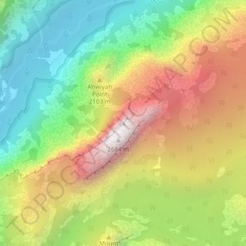
Nome: Mapa topográfico Half Dome, altitude, relevo.
Local: Half Dome, Mariposa County, California, United States (37.74595 -119.53330 37.74605 -119.53320)
Altitude média: 1.887 m
Altitude mínima: 1.241 m
Altitude máxima: 2.693 m
Faça uma doação
Outros mapas topográficos
Clique em um mapa para visualizar sua topografia, sua altitude e seu relevo.
Yosemite Valley
United States > California > Mariposa County > Yosemite Village
Altitude média: 2.016 m
Echo Valley
United States > California > Mariposa County
Echo Valley is a valley in Yosemite National Park, at an elevation of 7,021 feet (2,140 m). It is located along Echo Creek, about 3 miles (5 km) west of Merced Lake, at 37°44′38″N 119°26′03″W / 37.7438°N 119.4343°W / 37.7438; -119.4343. It is bounded on the south by the Merced River.
Altitude média: 2.333 m
Faça uma doação
Yosemite Valley
United States > California > Mariposa County > Yosemite Village
Altitude média: 2.012 m
Yosemite Valley
United States > California > Mariposa County > Yosemite Village
Altitude média: 2.016 m