
Mapa topográfico Alfdorf
Mapa interativo
Clique no mapa para exibir a altitude.
Sobre este mapa
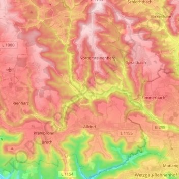
Nome: Mapa topográfico Alfdorf, altitude, relevo.
Local: Alfdorf, Rems-Murr-Kreis, Baden-Württemberg, 73553, Germany (48.81434 9.63179 48.91513 9.76976)
Altitude média: 476 m
Altitude mínima: 302 m
Altitude máxima: 575 m
The municipality (Gemeinde) of Alfdorf lies at the easternmost extremity of the Rems-Murr district, along its border with the Ostalb district. Alfdorf is physically located in the Schurwald and Welzheim Forest, regions of the larger Swabian-Franconian Forest. Elevation above sea level in the municipal area ranges from a high of 566 meters (1,857 ft) Normalnull (NN) to a low of 307 meters (1,007 ft) NN.[2]
Outros mapas topográficos
Clique em um mapa para visualizar sua topografia, sua altitude e seu relevo.
Winnenden
Germany > Baden-Württemberg > Rems-Murr-Kreis
Winnenden, Gemeindeverwaltungsverband Winnenden, Rems-Murr-Kreis, Baden-Württemberg, 71364, Germany
Altitude média: 331 m
Kaisersbach
Germany > Baden-Württemberg > Rems-Murr-Kreis
Kaisersbach, Vereinbarte Verwaltungsgemeinschaft der Stadt Welzheim, Rems-Murr-Kreis, Baden-Württemberg, 73667, Germany
Altitude média: 500 m
Waiblingen
Germany > Baden-Württemberg > Rems-Murr-Kreis
Waiblingen, Rems-Murr-Kreis, Baden-Württemberg, Germany
Altitude média: 285 m