
Mapa topográfico Airedale
Mapa interativo
Clique no mapa para exibir a altitude.
Airedale
This valley is of great topographic significance as it provides low-altitude passes through the mid Pennines to the west coast known as the Aire Gap.
Sobre este mapa
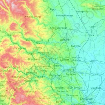
Nome: Mapa topográfico Airedale, altitude, relevo.
Altitude média: 58 m
Altitude mínima: 0 m
Altitude máxima: 372 m
Outros mapas topográficos
Clique em um mapa para visualizar sua topografia, sua altitude e seu relevo.
Stamford Bridge
United Kingdom > England > East Riding of Yorkshire > Stamford Bridge
Altitude média: 16 m