
Faça uma doação
Mapa topográfico Mount Rushmore National Memorial
Clique no mapa para exibir a altitude.
Faça uma doação
Mount Rushmore National Memorial
Mount Rushmore National Memorial is a national memorial centered on a colossal sculpture carved into the granite face of Mount Rushmore (Lakota: Tȟuŋkášila Šákpe, or Six Grandfathers) in the Black Hills near Keystone, South Dakota, United States. Sculptor Gutzon Borglum created the sculpture's design and oversaw the project's execution from 1927 to 1941 with the help of his son, Lincoln Borglum. The sculpture features the 60-foot-tall (18 m) heads of four United States Presidents recommended by Borglum: George Washington (1732–1799), Thomas Jefferson (1743–1826), Theodore Roosevelt (1858–1919) and Abraham Lincoln (1809–1865). The four presidents were chosen to represent the nation's birth, growth, development and preservation, respectively. The memorial park covers 1,278 acres (2.00 sq mi; 5.17 km2) and the mountain itself has an elevation of 5,725 feet (1,745 m) above sea level.
Faça uma doação
Sobre este mapa
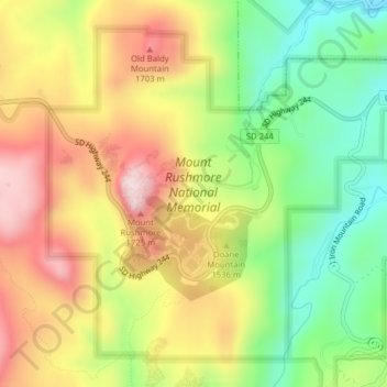
Nome: Mapa topográfico Mount Rushmore National Memorial, altitude, relevo.
Altitude média: 1.528 m
Altitude mínima: 1.343 m
Altitude máxima: 1.726 m
Faça uma doação
Outros mapas topográficos
Clique em um mapa para visualizar sua topografia, sua altitude e seu relevo.
Black Hills
United States > South Dakota > Pennington County
The Black Hills is an isolated mountain range rising from the Great Plains of North America in western South Dakota and extending into Wyoming, United States. Black Elk Peak, which rises to 7,242 feet (2,207 m), is the range's highest summit. The name of the range in Lakota is Pahá Sápa. It encompasses the…
Altitude média: 1.894 m
Mount Rushmore
United States > South Dakota > Pennington County
Mount Rushmore National Memorial is centered on a colossal sculpture carved into the granite face of Mount Rushmore (Lakota: Tȟuŋkášila Šákpe, or Six Grandfathers) in the Black Hills near Keystone, South Dakota. Sculptor Gutzon Borglum created the sculpture's design and oversaw the project's execution…
Altitude média: 1.562 m
Black Hills
United States > South Dakota > Pennington County
The Black Hills is an isolated mountain range rising from the Great Plains of North America in western South Dakota and extending into Wyoming, United States. Black Elk Peak, which rises to 7,242 feet (2,207 m), is the range's highest summit. The name of the range in Lakota is Pahá Sápa. It encompasses the…
Altitude média: 1.894 m
Faça uma doação
Black Elk Peak
United States > South Dakota > Pennington County
In September 2016, a team of professional surveyors obtained precise GNSS data over the course of two days and found the highest natural rock to be at 7,231.32 feet (2,204.11 m) NAVD88 and a nearby secondary peak located approximately 300 feet south of the lookout tower and unofficially named "McGillicuddy's…
Altitude média: 1.923 m
Pactola Reservoir Recreation Area
United States > South Dakota > Pennington County
Altitude média: 1.491 m
Faça uma doação
Faça uma doação