
Mapa topográfico Longnor
Clique no mapa para exibir a altitude.
Sobre este mapa
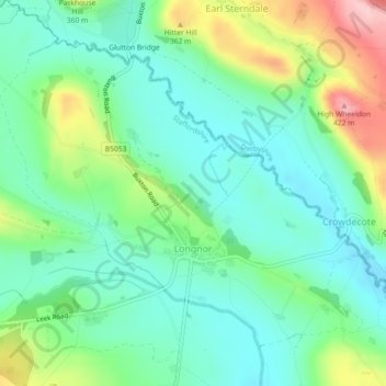
Nome: Mapa topográfico Longnor, altitude, relevo.
Altitude média: 295 m
Altitude mínima: 241 m
Altitude máxima: 420 m
Outros mapas topográficos
Clique em um mapa para visualizar sua topografia, sua altitude e seu relevo.
Biddulph Moor
United Kingdom > England > Staffordshire > Staffordshire Moorlands
Altitude média: 242 m
Stepping Stones
United Kingdom > England > Staffordshire > Staffordshire Moorlands
Altitude média: 224 m
Bottomhouse
United Kingdom > England > Staffordshire > Staffordshire Moorlands > Ipstones
Altitude média: 312 m
Roughcote
United Kingdom > England > Staffordshire > Staffordshire Moorlands > Caverswall
Altitude média: 217 m
Blackshaw Moor
United Kingdom > England > Staffordshire > Staffordshire Moorlands > Thorncliffe
Altitude média: 282 m
Endon Bank
United Kingdom > England > Staffordshire > Staffordshire Moorlands > Endon
Altitude média: 192 m
Lower Lee
United Kingdom > England > Staffordshire > Staffordshire Moorlands > Meerbrook > Lower Lee
Altitude média: 264 m
Horton
United Kingdom > England > Staffordshire > Staffordshire Moorlands > Gratton
Altitude média: 199 m
Rushton Spencer
United Kingdom > England > Staffordshire > Staffordshire Moorlands
Altitude média: 204 m
Old Hannah's Hole
United Kingdom > England > Staffordshire > Staffordshire Moorlands > Wetton
Altitude média: 276 m
Moneystone
United Kingdom > England > Staffordshire > Staffordshire Moorlands > Cotton
Altitude média: 231 m
Biddulph Grange Country Park
United Kingdom > England > Staffordshire > Staffordshire Moorlands > Biddulph > Biddulph Moor
Altitude média: 229 m
Moneystone Quarry
United Kingdom > England > Staffordshire > Staffordshire Moorlands > Kingsley > Whiston Eaves
Altitude média: 202 m
Rudyard Lake
United Kingdom > England > Staffordshire > Staffordshire Moorlands > Rudyard > Horton
Altitude média: 205 m
Hales Hall Pool
United Kingdom > England > Staffordshire > Staffordshire Moorlands > Cheadle
Altitude média: 182 m
Hope
United Kingdom > England > Staffordshire > Staffordshire Moorlands > Alstonefield
Altitude média: 274 m
Draycott Cross
United Kingdom > England > Staffordshire > Staffordshire Moorlands > Boundary
Altitude média: 183 m
Ladderedge Country Park
United Kingdom > England > Staffordshire > Staffordshire Moorlands > Leek
Altitude média: 176 m
Flash
United Kingdom > England > Staffordshire > Staffordshire Moorlands
Flash is a village in the Staffordshire Moorlands and the Peak District National Park, England. At 1,519 feet (463 m) above sea level, it is the highest village in the United Kingdom (some sources claim a height of 1,531 feet (467 m) for Wanlockhead in Scotland, but a survey in 2019 showed that there are no…
Altitude média: 412 m
CBeebies Land
United Kingdom > England > Staffordshire > Staffordshire Moorlands > Farley
Altitude média: 167 m
Dimmingsdale Valley
United Kingdom > England > Staffordshire > Staffordshire Moorlands > Alton
Altitude média: 177 m
Dovedale
United Kingdom > England > Staffordshire > Staffordshire Moorlands > Ilam
Altitude média: 271 m
The Winking Man
United Kingdom > England > Staffordshire > Staffordshire Moorlands > Upper Hulme
Altitude média: 380 m
Alton Castle
United Kingdom > England > Staffordshire > Staffordshire Moorlands > Alton
Altitude média: 154 m
Totmonslow
United Kingdom > England > Staffordshire > Staffordshire Moorlands > Huntley
Altitude média: 170 m
Huntley
United Kingdom > England > Staffordshire > Staffordshire Moorlands > Huntley
Altitude média: 178 m
Endon Basin
United Kingdom > England > Staffordshire > Staffordshire Moorlands > Endon
Altitude média: 179 m
Thor's Cave
United Kingdom > England > Staffordshire > Staffordshire Moorlands > Grindon
Altitude média: 270 m