
Obrigado por apoiar este site ❤️
Faça uma doação
Faça uma doação
Mapa topográfico Winterthur
Clique no mapa para exibir a altitude.
Obrigado por apoiar este site ❤️
Faça uma doação
Faça uma doação
Winterthur
Winterthur is located at an elevation of 439 meters (1,440 ft). The city is located in a basin south and east of the river Töss before it meets the High Rhine after 10 kilometers. The Eulach, a small river, flows from the town's east end through the middle of the town to meet the Töss at the west exit of the city. Because of this the town is colloquially also called "Eulachstadt". Zürich lies about 20 km (12 mi) southwest of Winterthur.
Obrigado por apoiar este site ❤️
Faça uma doação
Faça uma doação
Sobre este mapa
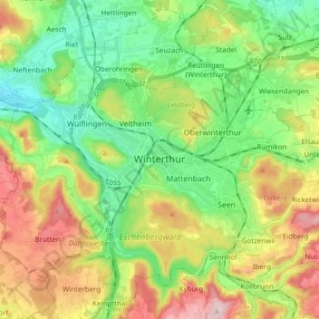
Nome: Mapa topográfico Winterthur, altitude, relevo.
Local: Winterthur, Bezirk Winterthur, Zurich, Switzerland (47.44972 8.65661 47.54800 8.80994)
Altitude média: 504 m
Altitude mínima: 390 m
Altitude máxima: 696 m
Obrigado por apoiar este site ❤️
Faça uma doação
Faça uma doação