
Obrigado por apoiar este site ❤️
Faça uma doação
Faça uma doação
Mapa topográfico Huesca
Clique no mapa para exibir a altitude.
Obrigado por apoiar este site ❤️
Faça uma doação
Faça uma doação
Huesca
Huesca lies on a plateau in the northern region of Aragón, with an elevation of 488 m (1,601.05 ft) above sea level. Close to the city lie the Sierra de Guara mountains, which reach 2,077 m. The geographical coordinates of the city are: 42° 08´ N, 0° 24´ W.
Obrigado por apoiar este site ❤️
Faça uma doação
Faça uma doação
Sobre este mapa
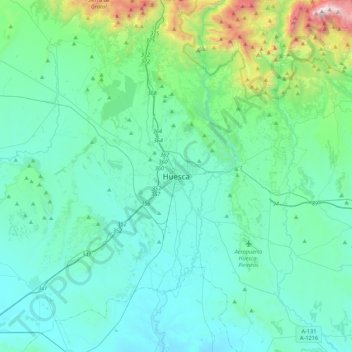
Nome: Mapa topográfico Huesca, altitude, relevo.
Altitude média: 589 m
Altitude mínima: 343 m
Altitude máxima: 2.062 m
Obrigado por apoiar este site ❤️
Faça uma doação
Faça uma doação