
Obrigado por apoiar este site ❤️
Faça uma doação
Faça uma doação
Mapa topográfico Thrippunithura
Clique no mapa para exibir a altitude.
Obrigado por apoiar este site ❤️
Faça uma doação
Faça uma doação
Thrippunithura
In the south, Thrippunithura borders the Vembanad, the longest lake in India. The lake provides facilities for inland water navigation, with the Champakkara canal stretch of the National Waterway 3 forming its western boundary with Kochi and Maradu. The canal then merges with the Chithrapuzha river in the north, near Irumpanam. Thrippunithura has an average elevation of 8 m (26 ft) above sea level, with the areas near Thiruvankulam in the easternmost boundaries rising to 30m.
Obrigado por apoiar este site ❤️
Faça uma doação
Faça uma doação
Sobre este mapa
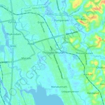
Nome: Mapa topográfico Thrippunithura, altitude, relevo.
Altitude média: 8 m
Altitude mínima: -5 m
Altitude máxima: 42 m
Obrigado por apoiar este site ❤️
Faça uma doação
Faça uma doação
Outros mapas topográficos
Clique em um mapa para visualizar sua topografia, sua altitude e seu relevo.