
Faça uma doação
Mapa topográfico Florence
Clique no mapa para exibir a altitude.
Faça uma doação
Sobre este mapa
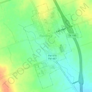
Nome: Mapa topográfico Florence, altitude, relevo.
Local: Florence, Williamson County, Texas, 76572, United States (30.82571 -97.80139 30.85085 -97.78123)
Altitude média: 305 m
Altitude mínima: 288 m
Altitude máxima: 330 m
Faça uma doação
Outros mapas topográficos
Clique em um mapa para visualizar sua topografia, sua altitude e seu relevo.
Soil Conservation Service Site 12 Dam
United States > Texas > Williamson County > Type
Altitude média: 173 m
Soil Conservation Service Site 12 Dam
United States > Texas > Williamson County > Type
Altitude média: 173 m
Faça uma doação
Soil Conservation Service Site 12 Dam
United States > Texas > Williamson County > Type
Altitude média: 173 m
Georgetown
United States > Texas > Williamson County > Georgetown
The city is located on the northeastern edge of Texas Hill Country. Portions of Georgetown are located on either side of the Balcones Escarpment, a fault line in which the areas roughly east of IH-35 are flat and characterized by having black, fertile soils of the Blackland Prairie, and the west side of the…
Altitude média: 228 m
Faça uma doação
Round Rock
United States > Texas > Williamson County > Round Rock
The city straddles the Balcones Escarpment, a fault line in which the areas roughly east of Interstate 35 are flat and characterized by having black, fertile soils of the Blackland Prairie, and the west side of the Escarpment, which consists mostly of hilly, karst-like terrain with little topsoil and higher…
Altitude média: 236 m