
Mapa topográfico Lilley
Clique no mapa para exibir a altitude.
Sobre este mapa
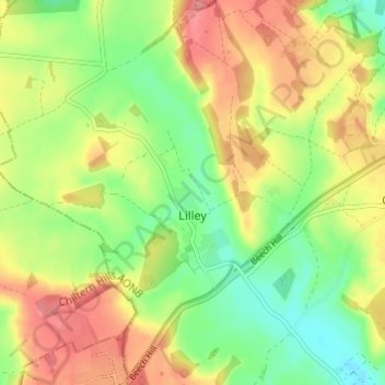
Nome: Mapa topográfico Lilley, altitude, relevo.
Altitude média: 148 m
Altitude mínima: 111 m
Altitude máxima: 187 m
Outros mapas topográficos
Clique em um mapa para visualizar sua topografia, sua altitude e seu relevo.
Temple Dinsley
United Kingdom > England > Hertfordshire > North Hertfordshire > Preston
Altitude média: 124 m
Letchworth
United Kingdom > England > Hertfordshire > North Hertfordshire > Letchworth
Altitude média: 80 m
Ashbrook
United Kingdom > England > Hertfordshire > North Hertfordshire > St Ippolyts
Altitude média: 85 m
Windmill Hill
United Kingdom > England > Hertfordshire > North Hertfordshire > Hitchin
Altitude média: 74 m
Bendish
United Kingdom > England > Hertfordshire > North Hertfordshire > Breachwood Green
Altitude média: 128 m
Knebworth Country Park
United Kingdom > England > Hertfordshire > North Hertfordshire > Knebworth
Altitude média: 116 m
Peter's Green
United Kingdom > England > Hertfordshire > North Hertfordshire > Kimpton
Altitude média: 133 m
Redcoats Green
United Kingdom > England > Hertfordshire > North Hertfordshire > Little Wymondley
Altitude média: 95 m
Cockernhoe
United Kingdom > England > Hertfordshire > North Hertfordshire > Offley > Cockernhoe
Altitude média: 149 m
Offley Hoo
United Kingdom > England > Hertfordshire > North Hertfordshire > Offley
Altitude média: 134 m
Ivel Springs Local Nature Reserve
United Kingdom > England > Hertfordshire > North Hertfordshire > Baldock
Altitude média: 72 m
Long Pond
United Kingdom > England > Hertfordshire > North Hertfordshire > Offley > Offley Hoo
Altitude média: 142 m
Knebworth Country Park
United Kingdom > England > Hertfordshire > North Hertfordshire > Knebworth
Altitude média: 116 m