
Faça uma doação
Mapa topográfico Mafeteng District
Clique no mapa para exibir a altitude.
Faça uma doação
Mafeteng District
In the west, Mafeteng borders on the Free State Province of South Africa. Domestically, it borders on the following districts Maseru District in the northeast and Mohale's Hoek District in the southeast. The Western districts of Lesotho has predominantly low land zone with an elevation of 1,500 m (4,900 ft) 1,800 m (5,900 ft) above the sea level. These lands are the major agricultural zones in the country. The average annual rainfall in the country is 100 cm (39 in), most of which is received during the rainy season of October to April. Though it rains during all the months of the year, groundwater is limited on account of run-offs. The region has a temperate climate on account of the elevation and is humid during most parts of the year. The temperature in low lands vary from 32 °C (90 °F) to −7 °C (19 °F) in the winter.
Faça uma doação
Sobre este mapa
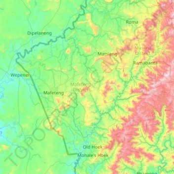
Nome: Mapa topográfico Mafeteng District, altitude, relevo.
Local: Mafeteng District, 900, Lesotho (-30.05834 27.01138 -29.52626 28.06544)
Altitude média: 1.761 m
Altitude mínima: 1.383 m
Altitude máxima: 3.041 m
Faça uma doação
Outros mapas topográficos
Clique em um mapa para visualizar sua topografia, sua altitude e seu relevo.